Tropical storm watch remains
Published 7:34 pm Wednesday, September 12, 2018
|
Getting your Trinity Audio player ready...
|
WAKEFIELD
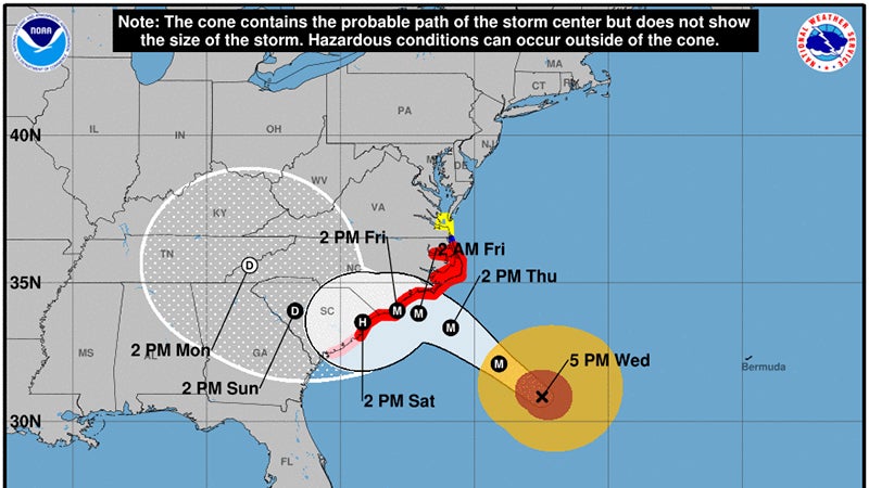
As of 7 p.m., Hurricane Florence remains a category 3 hurricane on the Saffir-Simpson wind scale, clocked at 120 mph, located at approximately 30.9 N 72.5 W. The National Hurricane Center’s forecast holds that the storm is projected to landing in southern North Carolina and northern South Carolina by early Friday. The tropical storm watch remains in effect for the coastal areas of the Tidewater region.
Wayne Albright, a senior forecaster with the NWS’s Wakefield station, said earlier on Wednesday that the city of Franklin and Southampton and Isle of Wight counties could see possible showers and thunderstorms for the rest of this week, with the likelihood increasing on Friday and Saturday. There should not be too much wind today and tomorrow, but 20 to 30 mph winds may occur on Friday going into Saturday, with possible gusts of between 35 to 40 mph.
Total rainfall for the region is now forecast at between 1 to 5 inches. Parts of Isle of Wight County near the James River may see storm surge of up to 2.5 feet departure from normal. This means a combination of 1 to 2 feet of surge from the hurricane, plus the effects of the tide and the impact of an anomaly the NWS has been tracking.
River flooding at the Blackwater or Nottoway should not occur until next week, if at all, depending on total rainfall.